Geographical Location of Uganda
Geographical Location of Uganda -Uganda is located on the edge of the Equator, positioned in south-central Africa, and bordered by the Democratic Republic of the Congo (DRC) in the west, Kenya in the east, Rwanda in the southwest, Sudan in north and Tanzania in the south.
Uganda is landlocked with no access to the sea with an average about 1,100 meters (3,609 ft.) above sea level and while much of its border is Lakeshore. The country is mostly plateau with some rolling hills and low mountains.
Grassland and tropical forest dominate the central region, with volcanic foothills in the east. The Ruwenzori Mountains form much of the southwestern border between Uganda and the DRC.
The highest peaks there are snow-capped. In eastern Uganda, the border with Kenya is marked by volcanic hills.
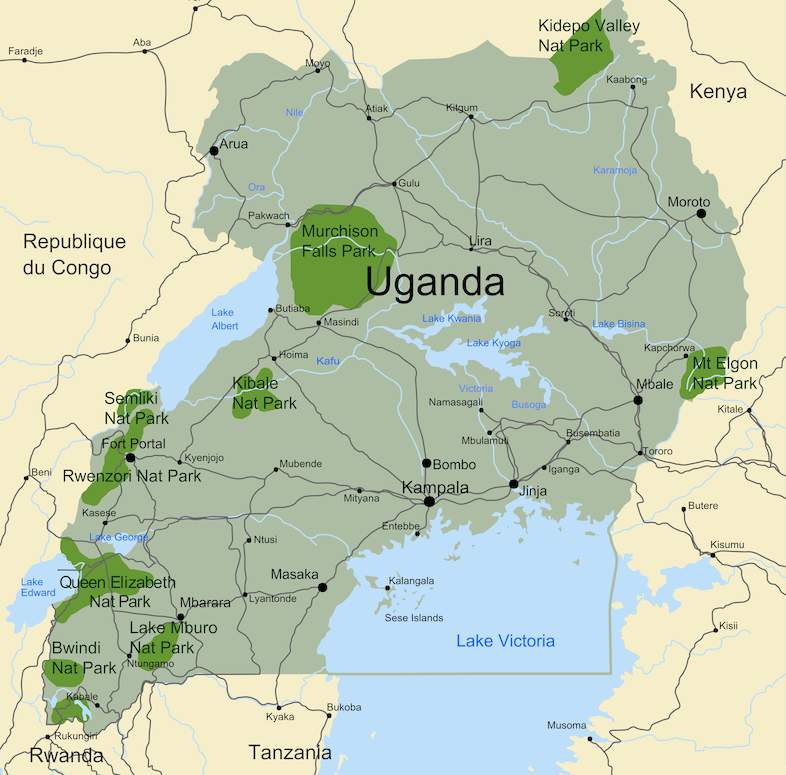
Uganda is replete with water and contains many large lakes. In fact, almost one-fifth of its total area is open water or swampland, meaning that Uganda holds the second biggest freshwater body in while of the world.
The famous four of East Africa’s Great Lakes – Lake Victoria, Lake Kyoga, Lake Albert, and Lake Edward lie within Uganda or on its borders. Lake Victoria is the second largest inland freshwater lake in the world (after Lake Superior), and it feeds the upper waters of the Nile River, which is referred to in this region as the Victoria Nile.
Lake Kyoga and the surrounding basin dominate central Uganda. Additional lakes of note include Lake Kwania, Lake Bugondo, Lake George and Lake Opeta.
The Nile River leaves Lake Victoria near Jinja, as the Victoria Nile. It flows for approximately 300 miles (500 km) further, through Lake Kyoga, until it reaches Lake Albert. After leaving Lake Albert, the river is known as the Albert Nile. It then flows into Sudan, where it is known as the Bahr al Jabal, or Mountain Nile.
The rolling hills of Kigezi sub-region adorned with terraces are a big spectacle as one traverses the gorilla homeland. This area’s scenery and cool conditions have made it be regarded as the ‘Switzerland of Africa’.
The hills inter twin and the valleys are deep and narrow, the terraces around the hills give them an extra touch. In the same region is the scenic lake Bunyonyi popular for its fascinating scenery and enormous bird life to which the lake is named.
The lake is a sanctuary for many bird species that inhabit its scattered islands. The lake is a perfect getaway for most visitors who seek to refresh and recuperate themselves after a tiresome safari or a strenuous gorilla trek. It is also a perfect spot for the honeymoon makers and those interested in birds.
The geographical location of tectonic forces in this area, wondrous features like the Sempaya hot springs was also formed.
The Sempaya hot springs features are amazing because of their varying temperatures, you will be left in awe when you see local people around bathing in the upper stream where water is warm.
The Sempaya hot springs are believed to cure all kinds of skin diseases while on the hotter spots, people are always busy boiling eggs and making porridge in an environment where you can never see any source of fire.
Caves and waterfalls that lie along some of its rivers that flow down slopes are some of the features that beautify this landscape.
Plenty of wildlife like buffalos, elephants, waterbucks and a number of primates inhabit the slopes of this mountain which led to the formation of Mt. Elgon national park to protect this wildlife.
The famous Murchison Falls that lies along this meandering river has been regarded as the hardest waterfalls in the world because of its force and depth.
At the top of the falls, the Nile crushes through an 8m wide gap before plunging down 42 m deep into the gorge, producing a thunderous roar and a rainbow that is very fascinating to see